Fuoriporta and the Quarter of Arco

Il Quartiere ArcoFrom Piazza Municipio, skirting the Tulliano building and turning down via Giuseppe Cesari, you reach a small square, on the left, named after St. Francesco Saverio Maria Bianchi.

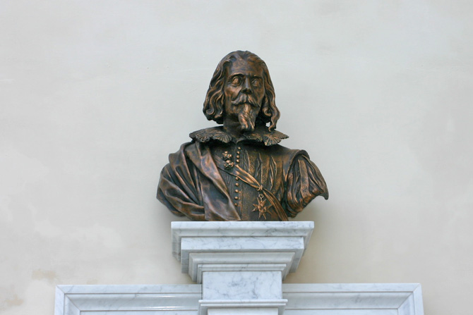
From the balcony on the back of the monument in memory of the Barnabite saint, it is possible to admire a noteworthy landscape of the quarter Civita Facolnara and of the cyclopean walls. Further on the left, a seventeenth century palace was the home of Giuseppe Cesari, called Cavalier d’Arpino (1568-1640). In the early 20th century, the outer wing of the building together with the ancient northern gate which interrupted the circle of the walls was pull down to allow a better access to the town. Yet, it is possible to see the narrow passage, located in the ground floor of the palace, which was once the entrance to Arpino.


Casa del Cavalier d'Arpino
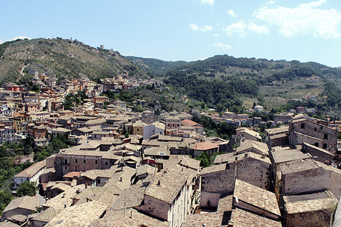
You are in the area called “Fuoriporta”, which is a real gate to the town. From the long tree-lined viale Belvedere, it is possible to enjoy a spectacular landscape of the valley (“vallone”) and of the surrounding hills set against the background of the Lepini and Ernici Mounts.

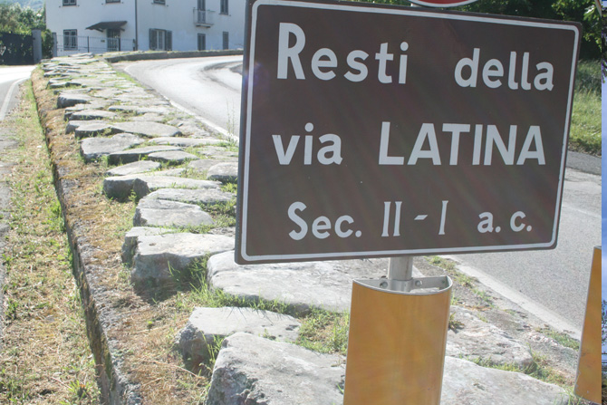
From the scenic terrace you can make out, half hidden by the green, the remains of a Roman tomb, which popular tradition identifies with the tomb of Saturn, the mytical founder of the town. On the opposite side of the street the iron sculptures made by the great artist Umberto Mastroianni are exhibited . At the top of the avenue, a staircase leads to the entrance to the secluded and charming church of Madonna delle Grazie .

Its airy and classical façade bears an ample pronaos, above which three big windows are to be seen. On the right, a ramp paved with cobble stones leads to via Arco Torrione, through which you arrive at the Qaurter Arco. On the left, there is the large building of the eighteenth century Institute of St. Vincenzo de’Paoli.

Here the built-area still preserve a Medieval character with a labyrinth of alleys and flights of steps, often chiselled in sheer stone,which has grown around ancient routes that linked the town centre with Civitavecchia.

Porta dell'ArcoThe visit begins from Porta dell’Arco, which once interrupted the circle of the polygonal walls, near an ancient turret. Today both the walls and the other fortifications are enclosed within the built-area.

Go along the narrow via Marco Agrippa from which many lanes branch off. At the end ther is  Salita dell’Arco, where an ample flight of steps links the street with piazza Municipio down below.

On the right the bell tower (nicknamed by the locals the “campanaro”) of St. Michele Arcangelo, raised over sheer rock, has a characteristic Neapolitan pendentive belfry.

On the left, via Greca winds up; it was cited by Cicero as a linking route with the Acropolis; it owes its name to the fact that it was probably built by Greek slaves.

Go back to “the campanaro” and down again to piazza Municipio.


Corso Tulliano and the quarter of Ponte

From Piazza Municipio turn down via del Liceo, then left and enter into Corso Tulliano, the main street of the old town centre. Established in 1884 it appears like a system of arcades (vaults) where a covered market takes place. On the right there is the birth house of the musician Carlo Conti, master of Vincenzo Bellini. On the left a small square where the palace of the Town Council stands with the war memorial (1927), a work by Domenico Mastroianni, a local renowned sculptor. Soon after, there is the elegant façade of Quadrini-Borromeo Palace (19th century), whose front is enriched by an ample wrought-iron gate. The palace houses the Circolo Tulliano, a social and cultural association established since 1886.


Further on the Merolle-Felluca Palace is the seat of the Town Library and  the Musem of stringed Instruments (see Museums).
On the left handside of the street, standing on its own, Sangermano Palace, built between 1879 and 1884, is surrounded by an ample park sloping down towards the Riviète stream. The Corso ends at Porta del Ponte, a Medieval remake of the ancient southern gate. On the left, the Gradelle Torrione winds up to the quarter Colle, skirting the Medieval turret, which was once enclosed within the circle of the walls. Because of the presence of the Riviète stream, this area has always been an industrial area: mills, tanneries, oil-mills were numerous and even today the remains of the buildings that housed them can be seen.

After Porta del Ponte and piazza Gioacchino Conti you come to via Vittoria Colonna. On the left you can read another page of the stone book, which is followed by the staircase leading to the baroque church of St. Anthony of Padua. Walking on the left, the former wool mill Sangermano was one of the most important in the town. In addition to the mill, the stone structure used to comprise the homes of the workers. Today, the building, which still preserve traces of its ancient history houses the Hotel Restaurant “Cavalier d’Arpino” and is partially occupied by private homes.


The quarter of Civita Falconara


Panorama di Civita Falconara Walking along via del Liceo, which starts from Piazza Municipio, you arrive at Civita Falconara. On the right, on the corner of via del Liceo and via Caio Mario stands the seventeenth century church of St. Croce, under restauration. In front of it, there is the majestic Eagle Fountain (17th century), featuring the town coat of arms with two towers and an eagle.

The quarter  is located on a rock spur which stands sheer above the valley underneath. This strategic position allowed in the past to guard the territory westwards up to the last spurs of the Lepini Mounts.

The Medieval structure with a range of alleys, arches and staircases winding up towards the rock, underwent many changes in the 18th century, during the blooming period of the town. We enter Civita Falconara on the left through via Caio Mario. Recent archaeological findings and documents suggest that even here stood a Volscian settlement, surrounded by its own fortifications of polygonal walls.

Fontana dell'Aquila RomanaStretches of polygonal walls are still visible at the beginning of viaa Caio Mario and since the Middle Ages have been enclosed within the inhabited area, as testified to by the tower standing near them. Going on you arrive by the small church of St. Rocco, built over a turret that was part of the ancient defence system.

Soon after, by the ample turn overlooking the precipice (Mezzaluna) you can admire the splendid landscape of the surrounding valleys and hills: on your left the towns of Monte San Giovanni, Boville Ernica and Veroli; on your right the Ernici Mounts followed by the Appennine mountain tops of the Abruzzo National Park divided by the Roveto Valley.

On the background the profile of the Lepini Mounts closes the view towards the Tyrrenean coast. Soon after the Mezzaluna, on the left, you can read another page of the stone book. On the same side there are the remains of the fortifications, over which the church of the Madonna of Loreto (18th century) with an octagonal plant and the monument to St. Francis of Assisi (1972) stand. Finally you arrive at the massive bulk of Ladislaus Castle (13th century). Originally called Castrum Pescli Facolnariae it was renamed after the long stay of  Naples’ king Ladislaus of Anjou-Durazzo in 1409, who had it fortified and established here a permanent garrison. Of the original building only few remains are left.

The main façade of the castle faces over Largo Riccia, another scenic point of the town. Going down one of the alleys on the left, you are in via Ciccodicola, the main roadway of the quarter, in which lanes and ramps join.

Castello di LadislaoWalking on you reach the square of Civita, the heart of the quarter, paved with the typical cobblestones. The airy façade of the church of St. Mary of Civita, with round and broken lines, niches and late baroque decorations, dates back to the 18th century. On the right, the fine bell tower is visible from any point in the town. Facing the church, the elegant airy façade of Quadrini Palace has the same curvilinear style.

On the left via di Civita is lined up with elegant, high-class buildings. On the left handside of the street there is Battiloro Palace.

The chain in front of its main entrance symbolizes the asylum right granted to the residence of the marquis Battiloro by Charles III during his stay in 1744. At its left via Battiloro leads to Poggio Quadrini and the "Caùto", over which typical courtyards line up. Going on along via di Civita you find the eighteenth century votive chapel called the “Madonnella”.

Santuario di Santa Maria di CivitaOther eighteenth and nineteenth century buildings face the street: on the left, the rusticated façade of Incagnoli Palace; on the right, the lond round structure of Morriconi Palace, decorated with wrought-iron railings.

In front of it another long and artistic balcony in wrought-iron embellishes and enriches the façade of Pesce Palace.